ROAD CLOSED 5 MILES AHEAD... ROAD CLOSED 7:30AM-4:30PM MON-FRI
Just waiting for the road to open
Seeing these words flash across a huge sign on the side of the road was not exactly what I wanted to encounter as I attempted to scout out the beginning miles of the Kaupo Gap trail with my crew. We drove approximately an hour on what is an incredibly beautiful but difficult to travel road. The road is a lane and a half at best, and what seems like less than a lane in many tight and twisting turns. We knew we were close to the turn off for the trail head, but we were unsure if it would come before the closure or not. It did not. At this point it was about 11am, the day before I was planning on running for the FKT. We stopped the car on the side of the road and spoke with the worker that was in charge of the closure. He told us that indeed the turn off to the trail head was about a mile past the closure, and that there was absolutely no way to get through until 4:30 pm. Okay, well there could be worse places to have to pass some time then on the beaches of Maui. After grabbing food and stopping on the beach we made our way back towards the trailhead when we quickly hit stopped traffic. After waiting for 30 minutes word had traveled from the front of the traffic that the road closure had been extened to 5:30 today. Okay, a little more waiting.
Once the road opened we were able to make it to the Kaupo general store where the road to the trail head turns off of the main road. It is really more like two tire tracks that have been paved. It was my first chance to see what some of the first mile or two that I would be running the next day looked like, and it was stunning! I was so excited!
We made it to the beginning of the trailhead and this is where the real fun of scouting the trail started! I read past trip reports which talk about the difficulty of these miles. Approximately miles 3-8 of the FKT route pass through private ranch land, with the ranch owners allowing the public through access up to the National Park boundary. Other reports mentioned guard dogs, extremely difficult terrrian, tough route finding, and wild boar trails. All of these previous reports were spot on!! I don't think I would be able to use words to describe how crazy/unique the first miles of the trail is. Here is a video of a section of the trail that you will encounter.
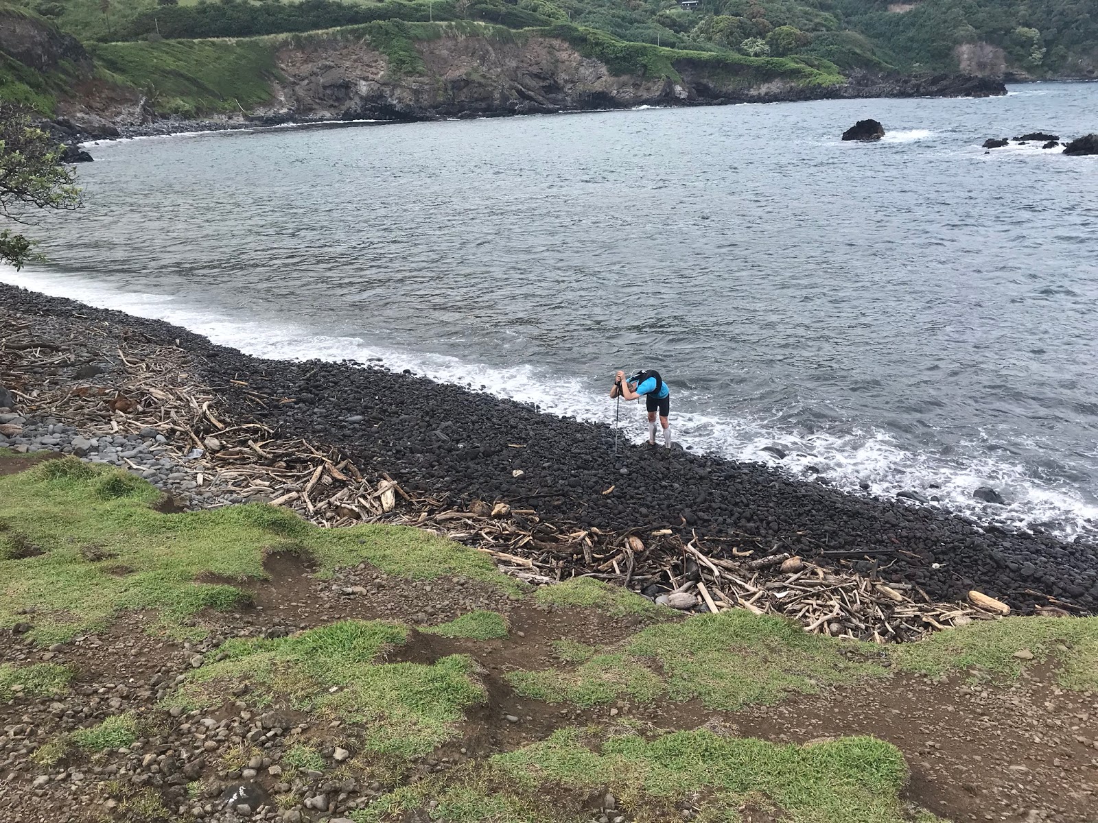
It took us about an hour to cover and scout the first .6 miles of the trail. There are National Park trail signs, but the blue flagging that someone previously put up proved to be the most helpful. The terrain is extremely rocky, with volcanic rock ranging from baseball to bowling ball size, covered by grass that is anywhere from knee to overhead height, with dozens of tiny small trails leading in all directions. It was of extreme value for me to see this section of the course before running it the next day. It gave me a chance to understand what I would be moving through. If I had encountered terrain like this for the first time on the day of the FKT attempt I think it would have been very difficult to deal with. Anyone attempting this route would serve themselves well by taking the time to check out this first section.
Checking out the trail
I included the description of the road closure and difficulty of the trail finding to highlight how remote/amazing/special this route is. It is on the less populated side of the island, the closest accommodation we could get was over an hour from the start, and this section of the trail is very rarely traveled. Yes it makes logistical planning for this route a little more difficult, but it also adds to the allure of getting to run such a special trail.
We wrapped up previewing what we could of the trail and it was time to head back to the AirBnB and get ready for the FKT attempt the next day.
A 4:30 alarm allowed us to get out of the door by 5:15am and make our way down to the start point at the beach below the church by about 6:15 am. Weather was looking good for the day, low 70's for the start, with predicted highs in the low 50's at the summit of Haleakala.
Watch Check: Starting at the ocean - 6:25am
With a double check of my gear, I told my crew thanks, and it was time to start. Even with a double check of my gear I forgot to start the day with a coating of sunscreen, which I would be regretting in the days to follow. Because my crew could drive the first 3 miles of the route to the beginning of the trail section, I decided to start without my pack, which I would pick up from them at that point.
As I started the run I could almost immediately feel the heat and humidity and I began sweating within a couple of minuets. After spending a long and cold winter in Seattle, I knew that the heat I would face could be difficult for me. I had spent the last month getting 4-5 sauna and steam room sessions a week in order to acclimate my body. Heat has given me problems with runs in the past, however I had never used a sauna for preparation. I started to sweat heavily within the first 20 minuets even as I held an easy effort level, but I reminded myself that as I climbed in elevation the temperature would cool. I also reminded myself that I just needed to execute my game plan of drinking whenever I felt the need and making sure I was taking my GU electrolyte and bcaa pills each hour. The Kaupo Gap was very prominent in the distance and I felt so excited about getting to spend a day moving up and down this mountain.
Time seemed to go quickly as I covered the first 3 miles along the road approaching the trail and before I knew it I saw my crew waiting at the gate to the beginning of the trail section. They told me they ran into the ranchers on their drive up and asked about the dogs. Apparently the ranchers were very friendly and indicated that as long as you stayed on the trail the dogs would be far away. This made me feel a little better.
Approaching the gate at Kaupo Ranch, 2.4 miles , about 900 ft elevation
Watch check: leaving gate at ranch property after picking up my pack
After 2.4 miles of road running you enter Kaupo Ranch and the real climbing begins. The next mile or so is the most difficult in terms of route finding. As I described earlier, the better you know this section of the trail, the faster you will be able to move through it. The vegetation that I was moving through was completely soaked with morning dew and I was quickly drenched head to toe. This was fine, however my soaked socks did end up giving me a hot spot / blister starting by about mile 6. After the mile or so of difficult route finding you get to follow 4x4 tracks that in some places are open and runable, and in other spots are so overgrown that it makes moving quickly very difficult, however easier to follow. The vegetation cuts at you. I wore calf compression sleeves and I feel this was a real help. The expossed part of my knee, below my shorts and above the calf compression, really got cut up. The same with my forearms. On the way up this was something I noticed less, however upon returning to this vegetation on the way down I was less than excited to be running through it.
Cuts from the vegetation through the calf compression
Cuts on the expossed part of my legs
Looking back toward the coast - 3.74 miles about 1,950 ft elevation. Everything was so wet, it was hard to get my touch screen to work!
Watch check: 7:30 am - 3.74 miles
By mile 4 you can begin to worry less about navigation and start to enjoy the views some more. The way that the vegetation changes as the elevation increases is really something to behold. This section of the trail was still difficult for me however. My heart rate was high for an easier effort level, my breathing felt labored and it was difficult to get a full breath. I was finding it tough to get into a good climbing pattern. I think I had been so excited and focused on this attempt for the previous 6 months that I was having a tough time calming myself down now that I was actually here and doing it! I continued to remind myself to believe in the winter of training I put in and to experience the mountain for what it gave me.
My plan for this FKT attempt was to keep it easy and steady on the way up, and to feel good enough to really run the way back down.
Looking at the views beginning to open up
At 5.5 miles you leave the Kaupo Ranch and enter Haleakala National Park. When I came upon the fence gate to the park there was a herd of about 20 cattle right in front of my exit. I made some noise and gave them some extra room as I moved towards the gate and getting around them proved to be no problem.
Watch Check: 8:09 am - 5.5 miles at the national park boundary
On the climb up to the national park boundary I ran some on the more open parts of the trail, and power hiked a lot. Once you cross into the park, the trail again becomes a little more technical and difficult to run. I mentioned the blue flagging before, and for the first mile inside the park the blue flagging was again very helpful. The terrain is very lush grass with a faint single track through it. You feel very special getting to travel in such an untouched terrain.
Inside of the park, about half way up the gap
From 5.5 miles to 9.3 miles you continue to climb through the Kaupo gap. As the elevation increased the trees noticeably started to thin out and lessen in size, the lava that you are running over becomes more noticeable in spots and you can sense that you are putting distance between yourself and the ocean. In this stretch I just worked on keeping a positive mental outlook, staying on top of calorie intake and keeping a steady power hike. You have to remind yourself in this section that the terrain will become less technical once you reach the crater and that you will be able to move a little faster on the way down. This is a section where if you can move quickly on very, very technical terrain you should be able to cut some time off of my attempt.
At 9.3 miles you hit the turn off to Paliku cabin and it really marks a change in terrain.
Watch Check: 9:25am - 9.29 miles
The trail is MUCH more runable at this point as the trail enters the crater and turns towards the west. There is no route finding that you will need to do as the trail is just beautiful single track through lava flow. At some points the trail is simply just the polished path of many feet traveling over a lava flow. At this point I was trying to run 60% of the time and power hike 40%. At 12.4 miles you hit Kapalaoa cabin and this is where the true beauty of the crater really starts to shine! My wife and I had done a backpacking trip to this cabin the previous September, which is when I had learned about the Kaupo gap trail and the Sea to Sky to Sea FKT. It was exiting to see this land mark, remember our previous visit, and think about the inspiration that trip had given me to do this run.
Watch Check: 12.42 miles @ Kapalaoa cabin - about 7,250 ft elevation
Pausing on the final climb out of the crater - about 1,750 left to climb
After you pass Kapalaoa cabin you get just over 2 miles of flat crater floor running. These miles are some of the most magical miles I have ever had the chance of running or getting to experience. Crossing the basin of the crater towards the final 2,500 ft climb towards the summit was just awesome. I put my headphones on and tried to run hard. As I hit the final climb up towards the summit I decided to just power hike every step. I wanted to arrive at the summit feeling good. I also knew that there are several false summits in the climb out and I didn't want to feel bothered by those. It felt awesome being able to settle into a good climbing hike and just feeling strong as I approached the summit. After 16 miles of only seeing 2 other people it felt different to be sharing the trail with more and more people as the summit approached.
Photo from my crew as I approach the summit along the road
At about 18.2 miles you come out of the crater to the visitor center, but there is still about .5 miles left to climb on road to the summit.
Touching Summit Sign!!
Watch Check: Summit at 11:52 - 5:26 elapsed
I didn't want to spend any longer than I needed at the summit, so I left quickly, planning to meet my crew for resupplying at the visitor center about 500 ft lower in elevation.
I met my crew at the visitor center for a quick refill of water, re-up on gels, cookies and a quick change out of my still wet socks. I tried to leave quickly and I was off headed back down into the crater. This section of the trail is so much fun to run! You have soft, relatively non-technical trail at a nice down hill grade. The views are unreal and the miles seemed to slip by. On my climb out of the crater I ran into a mule train bringing supplies down to one of the cabins. I stepped to the side and they passed in about one minute. I was worried that on my way back down into the crater I might be stuck behind them. Visibility into the crater was good, and each switch back I kept checking ahead to look for the mules. No sightings. I reached the crater floor and felt like I was moving well. The sun was out and I wanted to get across the crater floor and start descending more as soon as I could.
Watch Check: Kapalaoa Cabin second time
After you pass the cabin the terrain again becomes a little more rocky as the trail begins to descend. I hadn't seen anyone else for a couple of miles, and I would only pass one other hiker from this point on. About a mile past the cabin one of my poles got caught between two rocks and I had to pull with force to wedge it out. Looking at it I noticed the plastic cup surrounding the tip had been ripped off. Crazy! I had the same model poles for over 400 miles with no problems, and this was a brand new pair that had never been used prior to this run. About one mile later my pole again got stuck between two rocks and this time the carbide tip had broken off! Less than a mile after this, the pole again got stuck, and the top handle completely separated from the rest of pole! I was down to one pole. I tucked the broken one into my pack and continued on. A note on the poles: the first 10 miles of the climb the trail was either so over grown or narrow it was tough to use the poles. The second half they were very helpful.
Watch Check: Passing turnoff to Paliku Cabin on descent
At the junction for Paliku cabin you begin your descent back into the Kaupo gap. At this point I was feeling really good and just enjoying being on the mountain, having gone through the easier descent. The terrain now returns to a much more technical descent. I did my best to run as much as I could here, however at some points I had to resort to a quick hike just due to how difficult foot placement was at times. Again I think this is a point where someone with great technical running could make excellent gains on my time.
Watch Check: Leaving the national park, entering Kaupo Ranch
As I left the national park boundary there was now a herd of goats exactly where the cattle had been before. They quickly scattered as I got close to the gate. In the park boundaries I saw/heard quite a few birds but little other animal life. On the ranch side I encountered cattle, goats, an axis deer, a big ram, birds, and heard a pig moving right off of the trail. It was all really exciting! At this point I was just trying to move the best that I could through the terrain, and I was looking forward to the runable road of the last 2.4 miles. It was great to be able to see the coastline continue to get closer and closer as I descended through the again changing vegetation. The navigation and route finding of the last mile on the Kaupo ranch was still slightly challenging, but following the blue marking proved to be useful. I came onto the road and tried to move quickly down to the finish. The temperature was now about 83 degrees and I could notice it! I felt great as I wrapped up the last couple of miles. I turned down the road towards the starting point at the church and finished it up.
Watch Check: 9:16:43 - 37.65 miles
I finished in 9:16:43 setting a new FKT for the supported round trip of the Sea-to-Sky-to-Sea trail.
A big thanks to my crew Leah, Ethan, And Shannon. Without their help this effort would not have happened. Thank you!
A note on gear:
I carried about 3 litters of water up with me, using about 2 liters by the time I was at the summit. I packed a light wind breaker, but never used it. I forgot to wear a hat, and should have. I should have applied sunscreen at the beginning, not just at the summit. I brought sunglasses, and used them for a couple miles. Water usage on the descent was a little less than on ascent.


Congrats on an excellent run and new FKT! It was fun to relive the trail, I just love that whole area.
ReplyDelete